
|
Size: 1189
Comment:
|
← Revision 18 as of 2026-10-27 20:15:04 ⇥
Size: 5623
Comment:
|
| Deletions are marked like this. | Additions are marked like this. |
| Line 5: | Line 5: |
| .p19 1875 [[ https://en.wikipedia.org/wiki/Joseph_Gale | Joseph Gale ]] letter: Walla Met == grand river .p21 "intermittent fever" "ague" (influenza or malaria) 5000-6000 /or/ 90% of Indians died around lower Willamette and Columbia rivers .p21 no opposition to pioneer settlers .p22 [[ https://en.wikipedia.org/wiki/Atfalati | Atfalati ]] or Tualatin Indians, a [[ https://en.wikipedia.org/wiki/Kalapuya_people | Kapapuya ]] tribe .p22 "divine being" Ayuthlme-i an abstraction, like the word "miraculous" .p23 "purchase a wife" actually indemnity for the loss of a daughter's labor .p24 blankets and clothing and guns .p25 slaves of same owner allowed to marry; only sold (rarely) as a couple afterwards .p32 photo of 50 cm long stone knife (tip rounded, no point) .p33 Wapato Lake tribes, from Willamette river west to coast range, Forest Grove Hillsboro south to McMinnville Dayton .p84 1849 report 60 Tualatene Indians, 30 are warriors .p108 map showing 8x8 mile "square" (tilted 25 degrees west) of Tualaty Indians, approx Forest Grove to nw of Yamhill diagonal |
------ 35 notes ----- .'''p001 I. Introduction''' .p001 - 5000ya Campfire stone circle junction of Little Luckiamute and Luckiamute River, 44.791315N, 123.287490W .p013 - Map 1 from Melville Jacobs, "Kalapuya Texts", UW Press, 1945 [[ https://digital.lib.washington.edu/researchworks/items/beb83769-fafa-46c6-8958-f9fbc13dc12a/full | catalog of Melville Jacobs collection ]] .p014 - Kalapuya dialect simple, related in type to Coos .p015 - Indian name Wallamut, "spill or pour water" .p019 - 1875 [[ https://en.wikipedia.org/wiki/Joseph_Gale | Joseph Gale ]] letter: Walla Met == grand river .p021 - "intermittent fever" "ague" (influenza or malaria) 5000-6000 /or/ 90% of Indians died around lower Willamette and Columbia rivers, 5 miles SSW from Monmouth .p021 - no native opposition to pioneer settlers ----- .'''p022 II. Three Records of Kalapuya Culture''' .p022 - [[ https://en.wikipedia.org/wiki/Atfalati | Atfalati ]] or Tualatin Indians, a [[ https://en.wikipedia.org/wiki/Kalapuya_people | Kapapuya ]] tribe .p022 - "divine being" Ayuthlme-i an abstraction, like the word "miraculous" .p023 - "purchase a wife" actually indemnity for the loss of a daughter's labor .p024 - blankets and clothing and guns .p025 - slaves of same owner allowed to marry; only sold (rarely) as a couple afterwards .p028 - Indians considered a falsehood the greatest crime, punishment severe .p031 - stone club from Mary's Park [[ https://www.nwprd.org/parks | not on this list ]] , Wasco County, found embedded in 300 yo stump in 1884 .p031 - stone "knife" compared to New Zealand Māori patu club .p032 - photo of 50 cm long stone knife (tip rounded, no point) .p033 - Wapato Lake tribes, from Willamette river west to coast range, Forest Grove Hillsboro south to !McMinnville and .p036 - Non-obeyance of chiefs punished with death. ----- .'''p047 III. Willamette Valley Artifacts''' .p052 - rye-grass farmers are leveling and bulldozing Indian burial mounds .p054 - 1902, county tore down mound, dumped 12 skeletons in a ditch .p055 - 92 pound stone bowl, 16 inches across, indicates Indians "not exceedingly mobile" .p056 - Map of [[ https://ndnhistoryresearch.com/2017/08/01/mounds-of-the-tualatin-yamhill-kalapuyan-area/ | 120 Indian mounds ]] near Calapooia river between Tangent and Shedd, and Muddy Creek to the west .p077 - [[ https://en.wikipedia.org/wiki/Dentalium_shell | Dentalium ]] tooth or tusk shells .p078 - [[ https://en.wikipedia.org/wiki/Dentalium_shell| Dentalium littorina ]], toothpick-sized white shell .p079 - [[ https://en.wikipedia.org/wiki/Olivella_(gastropod) | Olivella gastropod shells ]] ----- .'''p082 IV. The Indians of the Willamette Valley and the United States Government''' .p082 - Indians expected Joseph Lane to pay for the land he took (1849), not strong enough to enforce demands .p083 - immigrant whites hunted all the deer, Camas Indians ate a farmer's ox, threatened with death .p084 - 1849 report ''60 Tualatene Indians, 30 are warriors'' .p088 - Tualatene indians west of Willamette, north of the Yamhill, east of the coast range .p094 - "our Government will provide them with land equally good beyond the Cascades" B.S. .p095 - alternative, an "equally good" swampy marsh, fine grazing for stock .p100 - Old map of territory "bought" from the Santiam band of the Callapooya Tribe, I estimate 1000 square miles, east of the Willamette, and north of current day Lebanon Oregon to Champoeg on the Willamette .p102 - '' ... Beginning at the mouth of a Small Creek emptying into the Wallamette River, a little below the Butte, in Marion County, thence up the Said Wallamette River with its meanders, to a point fifteen miles, above the mouth of the Kallapooya River, thence east to the base of the Cascade mountains; thence, northwardly along the base of the Cascade Range to the Moolale River, thence in a Westernly direction down Said River to a point due east from the place of the beginning, thence due West to the beginning.'' .p108 - map showing approx. 8x8 mile "square" (tilted 25 degrees west) of Tualaty Indians, approx Forest Grove to nw of Yamhill diagonal - About 60 Tualaty Indians sold 2000 square miles, moved to a 60 square mile reservation - [[ attachment:kalapuya.png | {{ attachment:kalapuya.png || height=400}}]] ( click image for full size ) - The current population of that area is more than a million people .p112 - ''... your great Father, thinks it would be better for both you and his white children, that you and they should live seperate and apart. (par.) He has, therefore, directed us if we can obtain your consent, to purchase all of your lands, in the Wallamette Valley, and remove to the east of the Cascade Mountains, or of the surrounding Indians, and be furnished with farming utensils, Cattle, Horses, and Clothing and means of subsistence, untill you can produce them yourselves in your new Home.'' .p116 - ''Friday Morning, 9 o'clock - May 2d Council met persuant to adjournment whereupon the following Treaty was read and fully explained and interpreted to the Chiefs who signed it willingly and with confidence'' .p120 - another "great father will pay you to move east of the Cascades" speech 1851 .p146 - An 1861 treaty moved all 50 remaining Kalapuyans and 5 other tribes to the [[ https://www.grandronde.org/ | Grand Rhonde ]] reservation .p146 - Sam Fern was the last full-blooded Kalapuyan, and died in 1919 at age 47 |
---
The Kalapuyans
Harold Mackey, PhD 1974
35 notes
p001 I. Introduction
- p001 - 5000ya Campfire stone circle junction of Little Luckiamute and Luckiamute River, 44.791315N, 123.287490W
p013 - Map 1 from Melville Jacobs, "Kalapuya Texts", UW Press, 1945 catalog of Melville Jacobs collection
- p014 - Kalapuya dialect simple, related in type to Coos
- p015 - Indian name Wallamut, "spill or pour water"
p019 - 1875 Joseph Gale letter: Walla Met == grand river
- p021 - "intermittent fever" "ague" (influenza or malaria) 5000-6000 /or/ 90% of Indians died around lower Willamette and Columbia rivers, 5 miles SSW from Monmouth
- p021 - no native opposition to pioneer settlers
p022 II. Three Records of Kalapuya Culture
- p022 - "divine being" Ayuthlme-i an abstraction, like the word "miraculous"
- p023 - "purchase a wife" actually indemnity for the loss of a daughter's labor
- p024 - blankets and clothing and guns
- p025 - slaves of same owner allowed to marry; only sold (rarely) as a couple afterwards
- p028 - Indians considered a falsehood the greatest crime, punishment severe
p031 - stone club from Mary's Park not on this list , Wasco County, found embedded in 300 yo stump in 1884
- p031 - stone "knife" compared to New Zealand Māori patu club
- p032 - photo of 50 cm long stone knife (tip rounded, no point)
p033 - Wapato Lake tribes, from Willamette river west to coast range, Forest Grove Hillsboro south to McMinnville and
- p036 - Non-obeyance of chiefs punished with death.
p047 III. Willamette Valley Artifacts
- p052 - rye-grass farmers are leveling and bulldozing Indian burial mounds
- p054 - 1902, county tore down mound, dumped 12 skeletons in a ditch
- p055 - 92 pound stone bowl, 16 inches across, indicates Indians "not exceedingly mobile"
p056 - Map of 120 Indian mounds near Calapooia river between Tangent and Shedd, and Muddy Creek to the west
p077 - Dentalium tooth or tusk shells
p078 - Dentalium littorina, toothpick-sized white shell
p079 - Olivella gastropod shells
p082 IV. The Indians of the Willamette Valley and the United States Government
- p082 - Indians expected Joseph Lane to pay for the land he took (1849), not strong enough to enforce demands
- p083 - immigrant whites hunted all the deer, Camas Indians ate a farmer's ox, threatened with death
p084 - 1849 report 60 Tualatene Indians, 30 are warriors
- p088 - Tualatene indians west of Willamette, north of the Yamhill, east of the coast range
- p094 - "our Government will provide them with land equally good beyond the Cascades" B.S.
- p095 - alternative, an "equally good" swampy marsh, fine grazing for stock
- p100 - Old map of territory "bought" from the Santiam band of the Callapooya Tribe, I estimate 1000 square miles, east of the Willamette, and north of current day Lebanon Oregon to Champoeg on the Willamette
p102 - ... Beginning at the mouth of a Small Creek emptying into the Wallamette River, a little below the Butte, in Marion County, thence up the Said Wallamette River with its meanders, to a point fifteen miles, above the mouth of the Kallapooya River, thence east to the base of the Cascade mountains; thence, northwardly along the base of the Cascade Range to the Moolale River, thence in a Westernly direction down Said River to a point due east from the place of the beginning, thence due West to the beginning.
- p108 - map showing approx. 8x8 mile "square" (tilted 25 degrees west) of Tualaty Indians, approx Forest Grove to nw of Yamhill diagonal
- - About 60 Tualaty Indians sold 2000 square miles, moved to a 60 square mile reservation
-
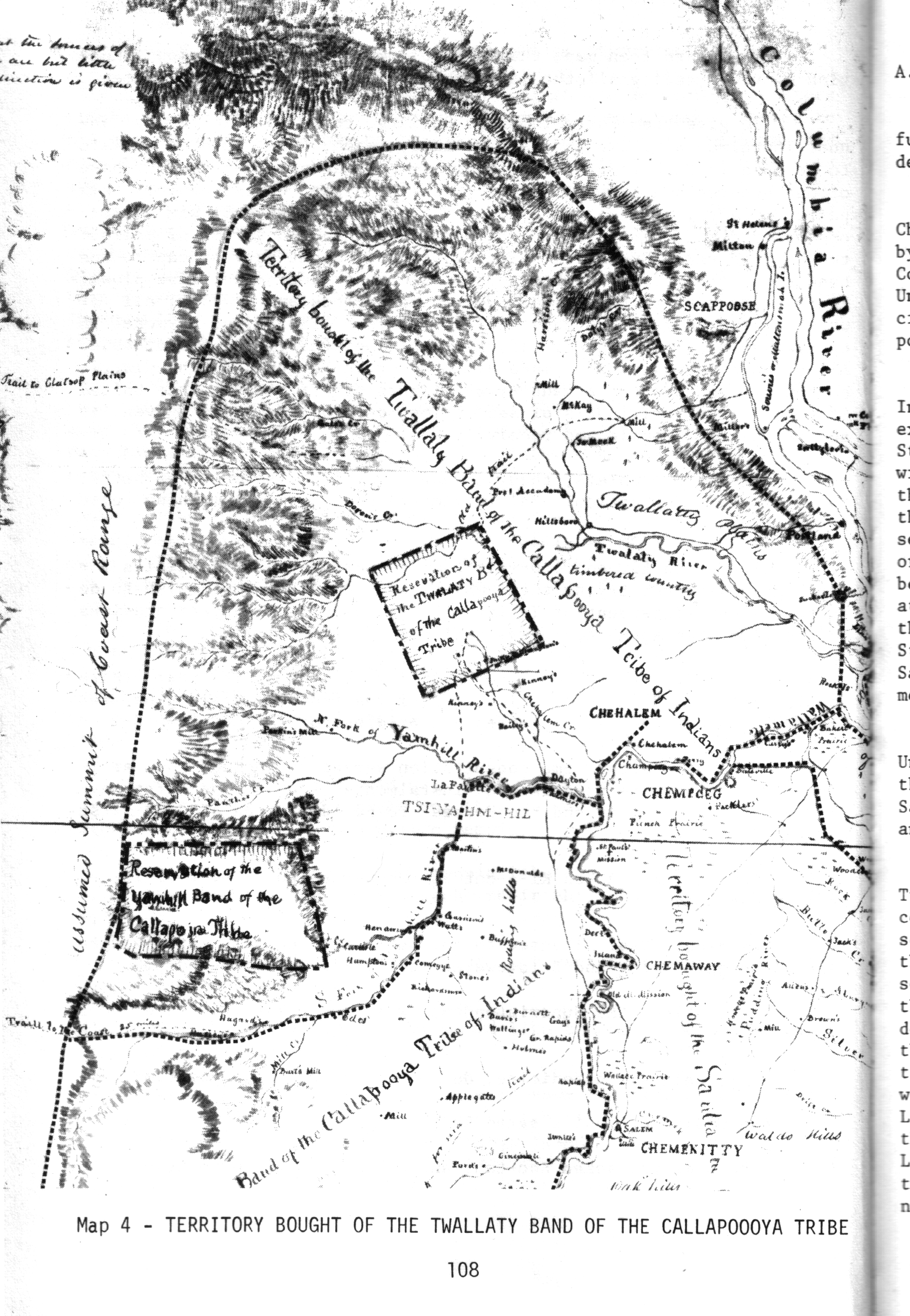 ( click image for full size ) - The current population of that area is more than a million people
- - About 60 Tualaty Indians sold 2000 square miles, moved to a 60 square mile reservation
p112 - ... your great Father, thinks it would be better for both you and his white children, that you and they should live seperate and apart. (par.) He has, therefore, directed us if we can obtain your consent, to purchase all of your lands, in the Wallamette Valley, and remove to the east of the Cascade Mountains, or of the surrounding Indians, and be furnished with farming utensils, Cattle, Horses, and Clothing and means of subsistence, untill you can produce them yourselves in your new Home.
p116 - Friday Morning, 9 o'clock - May 2d Council met persuant to adjournment whereupon the following Treaty was read and fully explained and interpreted to the Chiefs who signed it willingly and with confidence
- p120 - another "great father will pay you to move east of the Cascades" speech 1851
p146 - An 1861 treaty moved all 50 remaining Kalapuyans and 5 other tribes to the Grand Rhonde reservation
- p146 - Sam Fern was the last full-blooded Kalapuyan, and died in 1919 at age 47
